- Bus stop available
- free of charge / accessible at any time
Kütfelsen & Unitasquelle
Fountains | Excursion destinations
The Kütfelsen is considered Salzkotten's geological landmark and is a monument unique in Westphalia.


Address
Kütfelsen & Unitasquelle
Auf den Küten
33154 Salzkotten
Telephone: +49 5258 5070
Properties:
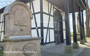
The Kütfelsen was formed by precipitation from the carbonated brine spring “Unitas.” The spring formed the more than three-meter-high, hourglass-shaped sinter rock on an open plain above the Heder gravel. The age of its lowest layers is estimated at more than 15,000 years. In the immediate vicinity stands the well house, built in 1554, which is a protected historic monument and was restored in 1980–81 with funding from the Westphalian Office for the Preservation of Historical Monuments. It was built directly over the brine spring to protect it.
Prices
freely accessible
Directions
The Kütfelsen rock formation, with its well house, is located in the center of Salzkotten, directly behind City Hall. Getting there by bus and train: Salzkotten Train Station www.bahnhof.de/salzkotten Nearest bus stop: “Salzkotten, Lange Straße” (approx. 350 m) Bus routes: 490, R46, S90, SK1, SK2, SK3 Public transportation information: HochstiftBewegt Nahverkehrsgesellschaft Hochstift mbH Tel. +49 5251 12 33 66 www.hochstiftbewegt.de